VIA BELVEDERE
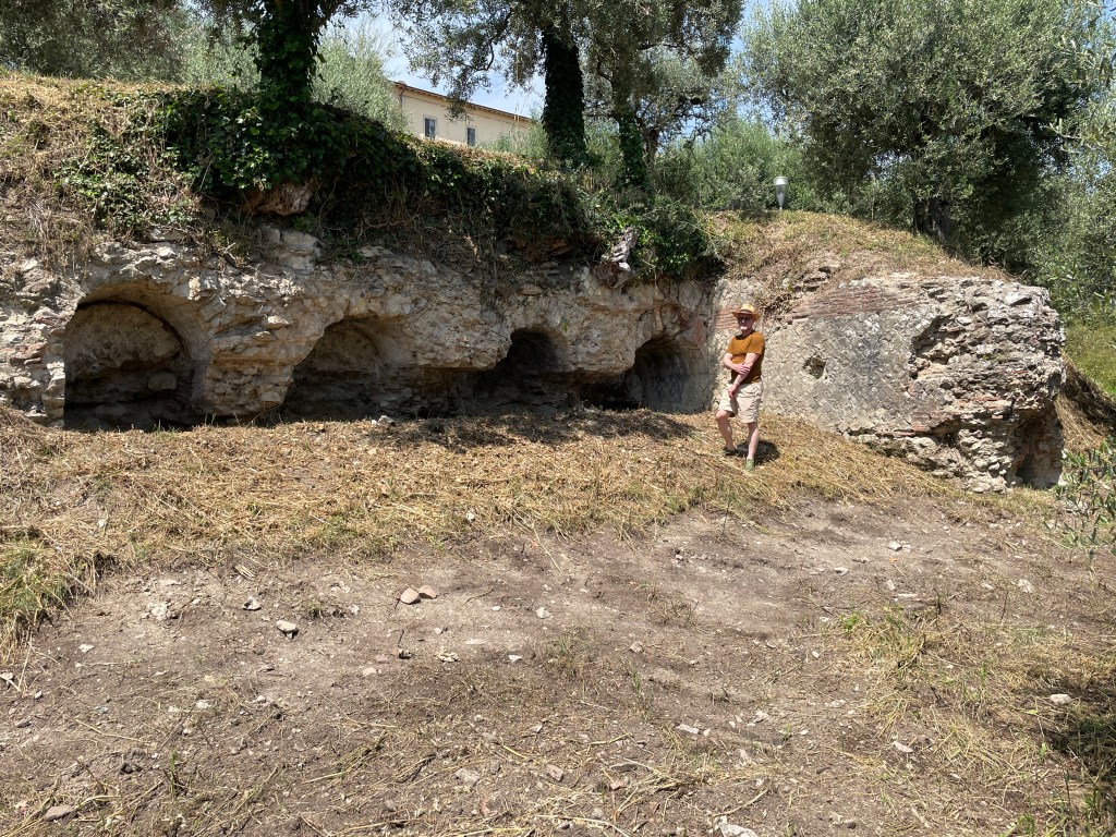
The Via Belvedere site, located on the south slope of the Castiglione del Lago promontory, preserves both Etruscan and Roman structures overlooking Lago Trasimeno. The Roman presence on the slope was known from the visible remains of an arched terrace wall on the lower part of the slope, perpendicular to which is an enclosed channel designed to drain water from higher up on the slope. Despite this known evidence of ancient activity on the promontory, no systematic excavation had occurred on the site until the TRAP team began digging in 2023.
Excavations, which are ongoing, have demonstrated that this part of the promontory was occupied in the Etruscan period. Hellenistic burials are present further to the east but the Via Belvedere site is the first indication of Etruscan activity not related to funerary practices. Both the structures and the artifacts recovered suggest that the promontory was the location of a previously undocumented Etruscan sanctuary. The Etruscan structures were destroyed by fire in the late 2nd century or early first century BC. The area was then abandoned for nearly 200 years. In the late 1st or early 2nd century AD, the Romans redevelop the lower part of the slope by constructing two massive terrace walls that support a monumental fountain house and bath complex. Like the earlier Etruscan structures, this complex likely had a sacred function associated with the lake and the display and control of fresh water.
In the late Antique or early Medieval period, the Roman structures are reused as a kiln site for making quicklime.
N.B. Excavations at the Via Belvedere site are ongoing. This page was last updated in August 2026 after the excavation campaign. Please check back for future updates.
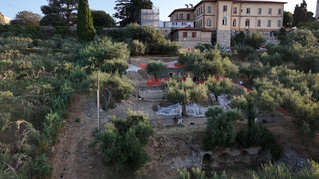
The ancient remains at the Via Belvedere site were preserved due to the construction, in the late 1700s, of modern terraces to support an olive grove. In some areas the fill is up to two meters deep. The lower Roman terrace wall, with the arches, is visible in the lower right of this drone photo. Fifteen meters to the north (ca. 50 Roman feet) is a second massive Roman terrace wall that doubles as the back wall of the bath complex and fountain house. The Etruscan remains, further to the north, were completely buried by the modern terracing.
The Etruscan Period
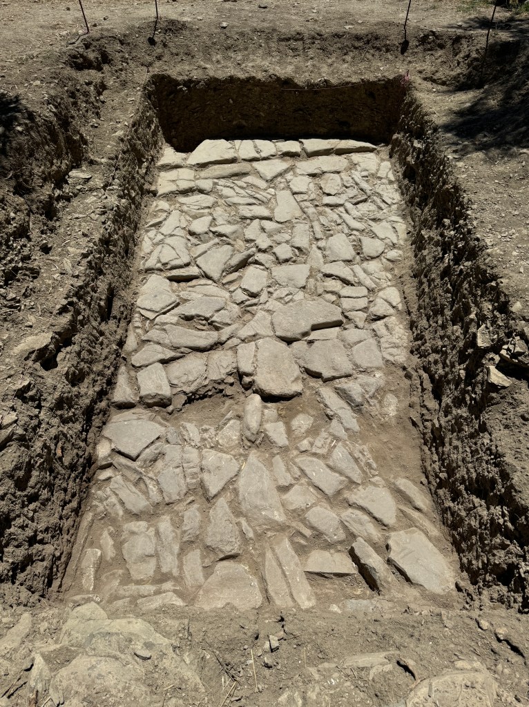
The Etruscan presence on the upper part of the slope was first identified by the discovery of a monumental cobble road, segments of which were uncovered in each excavation season. This road extends from the southwest towards the northeast and appears to be a type of processional way, guiding visitors arriving from the south towards the top of the promontory. The surface of the road is paved with selciato cobbles, a hard stone similar to basalt that is not local to Trasimeno. Cut stones along the north and south sides create a well-defined edge making the width of the road 4 meters. The materials and design of the road indicate significant effort and expense was devoted to its construction. In 2025, excavation extended north of the road and has now revealed an Etruscan retaining wall, protecting the road from erosion, and the corner of a large building that was destroyed by fire.
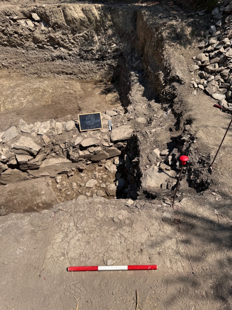
The retaining wall to the north of the road is constructed of large limestone blocks cut smooth on the exterior face but otherwise unworked. The blocks are laid without mortar. The wall is 80 cm wide but its overall length is not yet known. At the base of the wall, there is evidence of a gap in the stonework, probably to allow for water to drain in the event of a rainstorm. To the west, the retaining wall abuts the corner of a large building, only a small area of which was uncovered in the 2026 excavations (see photo below). Burnt roof tiles, wooden beams, and mudbrick indicate that the structure was destroyed in a major fire. It appears that this area of the site was then abandoned and covered over first by sediment that accumulated in the area and then, more intentionally, by a large desposit of stone material, probably waste from the construction of the Roman buildings.
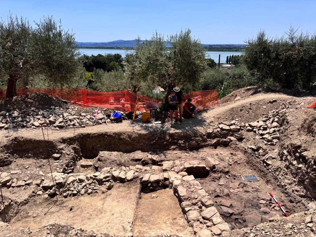
Pottery recovered from the sediment just above the road does not appear to date any later than the 2nd century BC. In other words, there is no evidence of Roman activity on the upper part of the slope after the destruction of the Etruscan structure. On the other hand, pottery from the fill just to the north of the wall includes some fine examples of Etruscan bucchero. The pottery is still being studied but may be as early as the 6th century BC. Other finds, such as fishing-net and loom weights, as well as some miniaturistic pottery forms and bronze fish hooks suggest dedications from a sacred site.
The Roman Period
After the destruction of the Etruscan building, the site appears to have been abandoned for nearly two centuries. Around AD 100, the Romans reconfigured the slope to support a monumental fountain house and bath complex. This project included the construction of the two massive terrace walls to created a wide and flat area for the structures. The terrace walls are aligned with the Etruscan road and the upper Roman wall backs up against and is cemented into the southern edge of the road. This suggests that the Romans were aware of the previous Etruscan use of the slope but chose not to reuse the Etruscan features (see plan below).
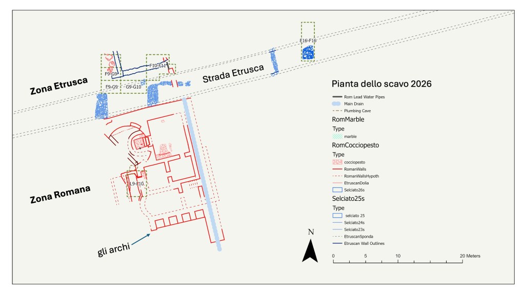
The Roman structures are designed to control and display water. The hemispherical fountain house (to the northwest in the plan) has a waterproof basin with an inlet pipe at the bottom and appears to have collected water piped from below. Water collected in the basin then fed a large pool in the room to the east. South of the fountain house and pool area, other rooms served as a caldarium (hot room, likely the apsidal structure in the southwest), a tepidarium (warm room), and possibly an apodyterium (a changing room). On the east side of the complex, a covered water channel provided drainage from the upper part of the slope.
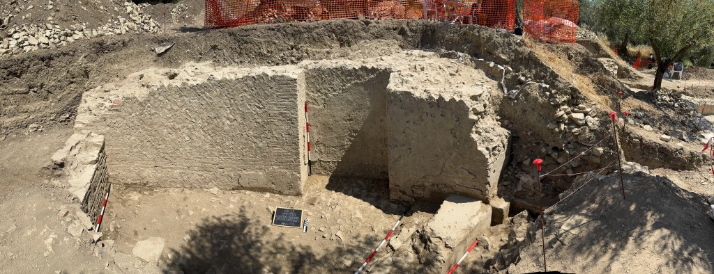
The scale of these features suggest that this was a monumental public structure, likely a water sanctuary that took advantage of the promontory’s position overlooking lake as well as the presence of fresh water from an artesian spring. The Roman remains at Via Belvedere recall other Roman water sanctuaries situated on lake shores, for example, the well-known sanctuary of Artemis on Lake Nemi.
Post-Roman to Medieval Activity
The Roman complex was abandoned in the late 2nd or early 3rd century AD. At some point, several rooms in the complex were reused as kilns and a kiln was built inside of Room A by using Roman tiles from the hypocaust of the bath. These kilns were used to produce quicklime in a process that starts by lining the area with charcoal, filling it with chipped limestone, and letting everything burn until an ashy powder remains. The powder can then be reconstituted with water to create concrete. The extensive production of quicklime on the slope of Castiglione del Lago probably supported the construction of the Medieval city walls in the 12th century.
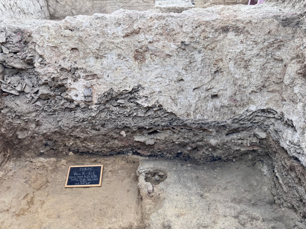
The image to the left, from Room B, shows a cross-section of kiln remains from the production of quicklime. The white, concrete layer at the top is the result of quicklime that was produced but never used. Over time it rehardened and, from above, gives the appearance of a thick layer of mortar,. Below the quicklime is a layer of limestone chips that are only partially burned and below that is visible the charcoal that was used to light the kiln.
In the 1700s, after the area had been abandoned for a long period of time, the slope was reterraced, using the alignment established by the Etruscans and the Romans, in order to plant an olive grove.
Excavations at the Via Belvedere site are ongoing. Please follow us on Instagram and Facebook for updates from the current season.
To support our research and teaching, please see our fundraising site.
To learn more about the field school and opportunities to participate, follow the link in the menu below.

